This is the first in a series of posts that follow the course we took from Thunderbolt, GA to Jekyll Island, GA, where our already long-delayed cruise got cut short AGAIN by an unfortunate SECOND lightning strike to poor Mulligan. The Parishes are fine, but Mulligan had to be towed back north to Thunderbolt, GA, where, as this is being posted, she is undergoing her second round of lightning repairs in a year.
 |
Natural beach on the north end of St. Catherine's Island, with its backdrop of lush piney woods. |
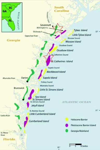
St. Catherine's is the fourth of Georgia's major sea islands. It lies south of Tybee, Wassaw and Ossabaw in a chain that runs all the way to Cumberland Island, which is located off the border of Georgia and Florida. The map below is the best we could find to show the area we covered in our week of travel. The red star shapes mark our starting and stopping points for Monday, June 20. (For more about Georgia's fascinating Holocene and Pleistocene barrier islands, take a look at: http://geology.uprm.edu/MorelockSite/morelockonline/5_image/GeorgCst.htm)
Note about Ossabaw, just north of our first night's anchorage: If you remember from a previous post, we were to have met up with a Chattanooga archeologist friend, Dr. Nick Honerkamp, at Ossabaw to see his summer 2011 dig there. Sadly, we missed that opportunity. Nick's project ended on June 16, and we didn't get underway again until June 19. We hope we'll get another chance someday.
St. Catherine's is largely a nature preserve administered by the New York Zoological Society, so the only parts of it that are currently public are its natural beaches, which were wide and white when we arrived, but not so wide when we left on the high tide the next morning. It's always amazing to us original landlubbers to see how the Georgia coastline changes appearance as its tides fluctuate from 8-10 feet every six hours!
Although you may not be able to see it on the map, the northwest corner of St. Catherine's is cut off from the rest of the island by Walburg Creek, which is where we anchored for the night. Walburg Creek can be entered from the north or from the west. We chose the north, because the west leg gets very shallow in places. We exited the same way the next morning, for the same reason.
Our anchorage was in sight of some of the Zoological Society's rehabilitation facilities where it cares for endangered African and Asian species such as kudus, hartebeests, lemurs and hornbills. We hoped to but did not get to glimpse any exotic creatures lurking on shore. Nevertheless, we enjoyed our night nestled in the lee of the island's "high ground"-- and "high" is a relative term when you're talking about the Georgia coast. We rested at anchor sheltered from the Atlantic and looking westward over Georgia's seemingly endless sea marshes.
Once we got anchored for the evening, it was still too hot to cook. Leftover pasta salad and more fresh tomato sandwiches did the trick. After dark, we lazed a while on Mulligan's trampoline, mesmerized by the stars. We always forget how much more intensely they burn and twinkle without the interference of ground light. The celestial light show made that night's anchorage even better, since it's one that human beings experience less and less frequently these days, we hear.
No comments:
Post a Comment